VALLEY FALLS STATE PARK
Once the site of a lumber and grist mill community, the scenic treasure of Valley Falls State Park is located only a short drive from Fairmont and Grafton. This 1,145 acre day use park hosts a variety of outdoor recreation including fishing, picnicking, whitewater rafting, and 18 miles of hiking and mountain biking trails.
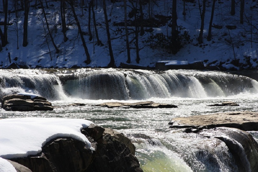
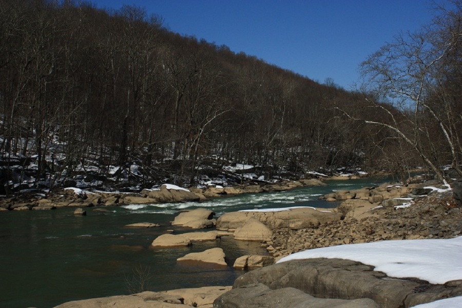
The beauty of the park is enhanced by the spectacular series of foaming falls which were created by the dark, rushing waters of the Tygart Valley River and provides a boundary between Marion and Taylor counties. The prevalent rock formation known as Connoquenessing Sandstone, forms the cap of the falls over which the river plunges and swirls and appears both as ledges and huge room size boulders for over a mile down the narrow canyon floor.
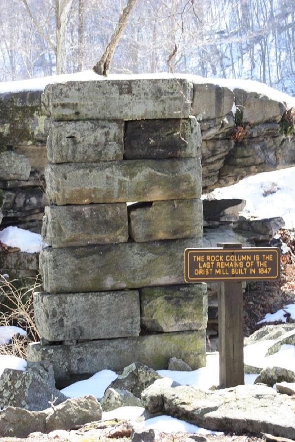
Before Valley Falls became a state park, this section of the Tygart Valley River in the 1800s was a thriving railroad community and a popular recreation area. During this "boom" period, Valley Falls had a B&O Railroad Depot Station, grist mill, post office, sawmills, shops and a ferry. Between 1886 and 1888, a fire and flood swept through the community. Some repairs were made but the town never fully recovered. In 1964, the state park system acquired the falls and the surrounding land. This picturesque river gorge became Valley Falls State Park.
Today Valley Falls State Park is a place of scenic beauty and historical significance and has continued to grow in popularity with both local and out of state visitors.
Anglers can enjoy river fishing along the Tygart Valley River, known for smallmouth bass, trout, and panfish species. Fishing is accessible year-round with appropriate licenses; catch-and-release practices are encouraged to preserve fish populations. The park offers serene spots perfect for casting a line amidst beautiful natural scenery.
Valley Falls State Park is located near Bridgeport, Clarksburg and Fairmont
Valley Falls State Park offers scenic picnic areas with tables and grills overlooking the Tygart Valley River's waterfalls.
When considering bicycling options, it's important to proceed with caution due to varying trail difficulties and conditions. The park offers several trails suitable for mountain biking; however, riders should be aware that some paths can be quite challenging.
The Rhododendron Trail is one option but note its technical terrain which may not suit beginners. For a more moderate ride, the Dogwood Trail presents fewer obstacles yet still requires attention to sudden changes in elevation.
Always check your equipment before hitting the Turtle Rock or Wild Turkey Trails as they demand well-maintained gear given their rough nature. It's advisable to have a map on hand since signage might not cover all junctions along these routes.
Lastly, stay alert for other users including hikers and wildlife while riding any path within the area-safety is paramount when sharing multi-use trails.
Hiking Trails
Tygart Valley River Trail - .2 mile. Mostly level with one steep incline.
Rhododendron Trail - 3.2 miles. Moderately steep near end, otherwise relatively easy.
Deer Trail - 2.1 miles. About 50% nearly level with modest up hill grade.
Red Cardinal Trail - 2 miles. All down hill from park entrance.
Dogwood Trail - .8 mile. Steep from Rhododendron Trail, then leveling off.
Wild Turkey Trail - 1.2 miles. Extremely steep from either end, otherwise follows near level ridge.
Red Fox Trail - .8 mile. Steep grade from Deer Trail.
From I-79, take Exit 137, then 310 south for 7 miles. Turn right at the Valley Falls State Park sign. Go two miles to the park entrance.


 Share Your Valley Falls State Park Photos (click here)
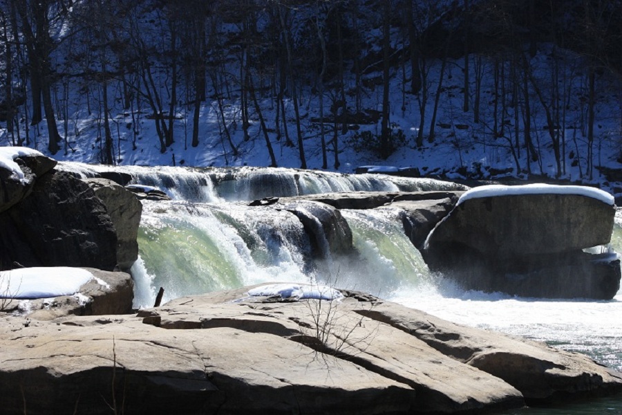